File:Soviet Caucasus map.svg
From WikiMANNia Commons

Size of this PNG preview of this SVG file: 712 × 600 pixels. Other resolutions: 285 × 240 pixels | 570 × 480 pixels | 912 × 768 pixels | 1,216 × 1,024 pixels | 747 × 629 pixels.
Original file (SVG file, nominally 747 × 629 pixels, file size: 731 KB)
Summary
| Description |
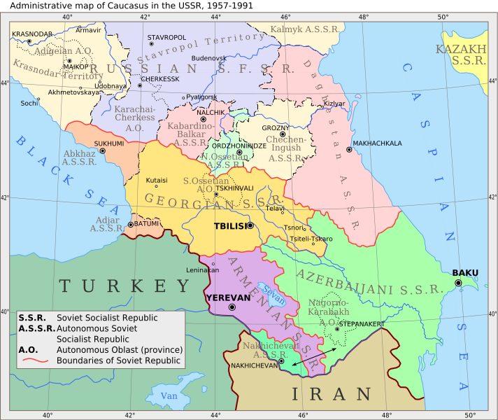
English: Administrative map of Caucasus in USSR, 1957-1991 |
| Date | (UTC) |
| Source | |
| Author |
|
| Other versions |
 |
| This is a retouched picture, which means that it has been digitally altered from its original version. Modifications: Vectorization. The original can be viewed here: Caucasiamapussr.gif:
|
Licensing
I, the copyright holder of this work, hereby publish it under the following licenses:
| This file is licensed under the Creative Commons Attribution-Share Alike 3.0 Unported license. | ||
| ||
| This licensing tag was added to this file as part of the GFDL licensing update. |

|
Permission is granted to copy, distribute and/or modify this document under the terms of the GNU Free Documentation License, Version 1.2 or any later version published by the Free Software Foundation; with no Invariant Sections, no Front-Cover Texts, and no Back-Cover Texts. A copy of the license is included in the section entitled GNU Free Documentation License. |
You may select the license of your choice.
Original upload log
This image is a derivative work of the following images:
- File:Caucasiamapussr.gif licensed with Cc-by-sa-3.0-migrated, GFDL
- 2011-03-27T04:49:14Z Hellerick 700x590 (82529 Bytes) The earlier changes were correct.
- 2011-01-16T19:12:39Z Geagea 700x590 (60613 Bytes) Reverted to version as of 10:16, 24 February 2007. To the uploader's last version
- 2011-01-16T18:38:27Z Nicolay Sidorov 700x590 (82529 Bytes) Adygea to Krasnodar, Karachay-Cherkess to Stavropol.
- 2011-01-16T18:31:42Z Nicolay Sidorov 700x590 (82116 Bytes) The Chechen-Ingush republic was restored on January 9, 1957
- 2007-02-24T10:16:08Z Hardscarf 700x590 (60613 Bytes) {{Information |Description=Administrative map of [[:en:Caucasus]] in USSR, 1952-1991 |Source=Armenica.org {{ConfirmationImageOTRS|source=http://armenica.org/|otrs=2007010210006387}} Originally from [http://en.wikipedia.org en
Uploaded with derivativeFX
File history
Click on a date/time to view the file as it appeared at that time.
| Date/Time | Thumbnail | Dimensions | User | Comment | |
|---|---|---|---|---|---|
| current | 11:37, 14 June 2017 | | 747 × 629 (731 KB) | Hellerick | moved Grozny; replaced Prokhladni with Pyatigorsk |
File usage
There are no pages that use this file.
