File:Danube 1940-1948.svg
From WikiMANNia Commons

Size of this PNG preview of this SVG file: 800 × 360 pixels. Other resolution: 320 × 144 pixels.
Original file (SVG file, nominally 2,748 × 1,238 pixels, file size: 15 KB)
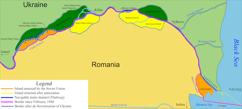
Deutsch: Grenzverlauf und Annexionen von Inseln im Donaudelta seit 1940/48
English: Borders and annexations of islands in the Danube Delta since 1940/48
Español: Fronteras y anexiones de las islas del delta del Danubio desde 1940/48
Français: Frontières et annexions d'îles dans le delta du Danube depuis 1940/48
Italiano: Confini e annessioni di isole nel Delta del Danubio dal 1940/48
Русский: Границы и аннексии островов в дельте Дуная с 1940/48 гг.
This file is translated using SVG
<switch> elements. All translations are stored in the same file! Learn more.
To embed this file in your language (if available) use the |
File history
Click on a date/time to view the file as it appeared at that time.
| Date/Time | Thumbnail | Dimensions | User | Comment | |
|---|---|---|---|---|---|
| current | 03:46, 28 October 2024 |  | 2,748 × 1,238 (15 KB) | Admin (Germany) (talk | contribs) | https://commons.wikimedia.org/wiki/File:Danube19401948.svg |
You cannot overwrite this file.
File usage
There are no pages that use this file.
