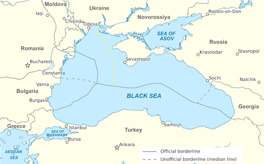
File:Exclusive Economic Zones in the Black Sea.svg
From WikiMANNia Commons

Size of this PNG preview of this SVG file: 532 × 330 pixels. Other resolution: 320 × 198 pixels.
Original file (SVG file, nominally 532 × 330 pixels, file size: 144 KB)
Deutsch: Karte der ausschließlichen Wirtschaftszonen im Schwarzen Meer
Durchgezogen: Vereinbarte Grenzverläufe. Gestrichelt: Inoffizielle Grenzverläufe
English: Map of the exclusive economic zones in the Black Sea
Solid lines: Agreed borders. Dashed: Unofficial borders
Español: Mapa de las zonas económicas exclusivas del Mar Negro
Líneas continuas: Fronteras acordadas. Líneas discontinuas: Fronteras no oficiales
Français: Carte des zones économiques exclusives de la mer Noire
En trait plein : Frontières convenues. En pointillés : frontières non officielles.
Italiano: Mappa delle zone economiche esclusive nel Mar Nero
Linee continue: Confini concordati. Linee tratteggiate: confini non ufficiali
Русский: Карта исключительных экономических зон в Черном море
Сплошные линии: Согласованные границы. Пунктирные: неофициальные границы
- Author
- Original: Tentotwo; Multi language: WikiMANNia
- License
- Creative Commons Attribution-Share Alike 3.0 Unported
- Source
- https://commons.wikimedia.org/wiki/File:Ausschliessliche_Wirtschaftszonen_Schwarzes_Meer.svg
This file is translated using SVG
<switch> elements. All translations are stored in the same file! Learn more.
To embed this file in your language (if available) use the |
File history
Click on a date/time to view the file as it appeared at that time.
| Date/Time | Thumbnail | Dimensions | User | Comment | |
|---|---|---|---|---|---|
| current | 20:40, 7 September 2024 |  | 532 × 330 (144 KB) | Admin (Germany) (talk | contribs) | https://commons.wikimedia.org/wiki/File:Ausschliessliche_Wirtschaftszonen_Schwarzes_Meer.svg |
You cannot overwrite this file.
File usage
There are no pages that use this file.
