File:Map of Southern Russia.svg
From WikiMANNia Commons

Original file (SVG file, nominally 1,092 × 872 pixels, file size: 215 KB)
Föderationskreise Wolga[wp] und Zentralrussland[wp]
Föderationskreis Nordkaukasus[wp]
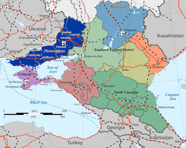
- Föderationskreis Südrussland
Republik Adygeja[wp]
Oblast Astrachan[wp]
Oblast Wolgograd[wp]
Republik Kalmückien[wp]
Region Krasnodar[wp]
Oblast Rostow[wp]
Republik Krim
Neurussland (Volksrepublik Donezk, Volksrepublik Lugansk, Oblast Melitopol, Oblast Kachowka)
Oblastgrenzen aus dem Jahr 2010
Federal Districts Volga[wp] und Central[wp]
North Caucasian Federal District[wp]
- Southern Federal District
Republic of Adygea[wp]
Astrakhan Oblast[wp]
Volgograd Oblast[wp]
Republic of Kalmykia[wp]
Krasnodar Krai[wp]
Rostov Oblast[wp]
Republic of Crimea
Novorossiya (Donetsk People's Republic, Lugansk People's Republic, Melitopol Oblast, Kakhovka Oblast)
Oblast boundaries from 2010
Приволжский федеральный округ[wp] и Центральный федеральный округ[wp]
Северо-Кавказский федеральный округ[wp]
- Южный федеральный округ
Респу́блика Адыге́я[wp]
Астраханская область[wp]
Волгоградская область[wp]
Респу́блика Калмы́кия[wp]
Краснодарский край[wp]
Ростовская область[wp]
Республика Крым
Новороссия (Донецкая Народная Республика, Луганская Народная Республика, Мелитопольская область, Каховская область)
Границы областей с 2010 года
- License
- Creative Commons Attribution-Share Alike 4.0 International
This file is translated using SVG
<switch> elements. All translations are stored in the same file! Learn more.
To embed this file in your language (if available) use the |
File history
Click on a date/time to view the file as it appeared at that time.
| Date/Time | Thumbnail | Dimensions | User | Comment | |
|---|---|---|---|---|---|
| current | 00:47, 16 February 2025 | | 1,092 × 872 (215 KB) | Admin (Germany) (talk | contribs) | add "it" |
| 10:31, 12 February 2025 |  | 1,092 × 872 (234 KB) | Admin (Germany) (talk | contribs) |
You cannot overwrite this file.
File usage
There are no pages that use this file.
