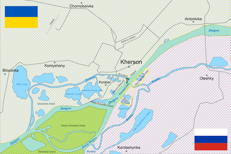
File:Map of the area around Kherson.svg
From WikiMANNia Commons

Size of this PNG preview of this SVG file: 800 × 534 pixels. Other resolution: 320 × 214 pixels.
Original file (SVG file, nominally 1,900 × 1,268 pixels, file size: 41 KB)
Deutsch: Karte der Umgebung von Cherson: Der Dnepr[wp] und die Große-Potemkin-Insel sind Teil der binationalen Zone
, die Kleine-Potemkin-Insel bleibt ausgenommen.
English: Map of the area around Kherson: Der Dnieper[wp] und die Velykyi Potomkin Island[wp] sind Teil der binational zone
, die Malyi Potomkin Island bleibt ausgenommen.
Español: Mapa de los alrededores de Jersón: El Dniéper[wp] y la isla Gran Potemkin forman parte de la zona binacional
, mientras que la isla Pequeña Potemkin queda excluida.
Français: Carte de la région autour de Kherson: Le Dniepr[wp] et la Grande Île Potemkine[wp] font partie de la zone binationale
, la Petite Île Potemkine en est exclue.
Italiano: Mappa dell'area intorno a Kherson: Il Dnepr[wp] e la Grande Isola Potemkin fanno parte della zona binazionale
, mentre la Piccola Isola Potemkin ne rimane esclusa.
Русский: Карта окрестностей Херсона: Днепр[wp] и Большой Потёмкинский остров[wp] являются частью двунациональной зоны
, Малый Потёмкинский остров остается исключением.
- Deutsch
- Binationale Zone
- English
- Binational zone
- español
- Zona binacional
- français
- Zone binationale
- italiano
- Zona binazionale
- русский
- Двунациональная зона
This file is translated using SVG
<switch> elements. All translations are stored in the same file! Learn more.
To embed this file in your language (if available) use the |
File history
Click on a date/time to view the file as it appeared at that time.
| Date/Time | Thumbnail | Dimensions | User | Comment | |
|---|---|---|---|---|---|
| current | 10:03, 1 November 2025 | | 1,900 × 1,268 (41 KB) | Admin (Germany) (talk | contribs) |
You cannot overwrite this file.
File usage
There are no pages that use this file.
